Old Weld County 1859 - 1887
Weld County's history is vast and stretches back to the 1800s. In this section, travel back in time to where it all began to find out more about how the county was formed and what it looked like when it was a territory.
 Beginning in the early 1800s Westward expansion brought trappers, traders, miners, ranchers and eventually farmers and merchants who built over 100 communities in what would become Weld County. A variety of towns, all with different stories, were built, expanded, torn down, rebuilt, moved, or just plain vanished from what had once been Indian Territory (see map 1).
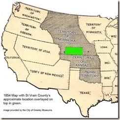
In 1854, in what would later become Weld County, Nebraska and Kansas Territories were divided along what is now Weld County Road 2; Nebraska to the north, Kansas to the south (see map 2). The largest water source here was the South Platte River, which had a well worn trail for natives and wildlife. Then gold was found along the South Platte River near present day Denver, creating a rush of miners and some settlers into the area traveling the South Platte River Trail.
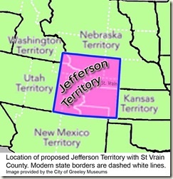
 Miners and settlers voted to form their own territory made from parts of both Kansas and Nebraska Territories in 1859. It was named Jefferson Territory (see map 3), with 12 counties, including St. Vrain County, named in honor of the French traders, Ceran and his brother Marcellaine St. Vrain, who had the fourth trading post on the upper South Platte River, often called St. Vrains.
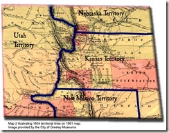
 Jefferson Territory was not accepted by the U. S. Congress. Instead, on February 28, 1861, just four days before the end of his presidency, James Buchanan signed the legislation organizing Colorado Territory. Colorado Territory covered much the same land as Jefferson Territory but shaved the border to the north by 1º and the south by 2º.
 September 9, 1861, St. Vrain County was officially renamed Weld County with the town of St. Vrain remaining the county seat. Weld County was named in honor of Lewis Ledyard Weld, Colorado Territorial Secretary under Colorado’s first territorial governor. Weld later died during his military service during the Civil War. On November 1, 1861, the Colorado Territory’s General Assembly organized and ratified 17 counties, including the newly renamed Weld County. This is the day considered to be the date Weld County began.
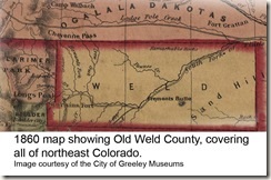
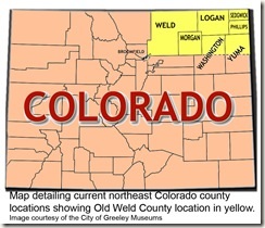 Old Weld County’s original territory was vast, encompassing seven other modern counties (see map 5). Counties began splitting off from Weld starting with Washington - February 9, 1887; Morgan– February 19, 1887; Logan - February 25, 1887; and Yuma on March 15, 1889. Two counties split from Logan in 1889; Phillips – March 27 and Sedgwick – April 9 and Washington and Yuma Counties added territory from Adams and Arapahoe Counties on April 10, 1903.
The latest to separate from Weld County was Broomfield. Incorporated as a municipality in southeast Boulder County Broomfield eventually grew into Weld, Adams and Jefferson counties. To alleviate problems stemming from lying in four counties the City and County of Broomfield was officially ratified by the State of Colorado, splitting away from Weld, November 15, 2001.
The above information is gleaned from the book, Weld County Towns: The First 150 Years, researched by the City of Greeley Museums staff, Nancy Lourine Lynch, head writer.