Original Surveying of Weld County
by Leon Sievers,
Professional Land Surveyor with the Weld County Public Works Dept.
In 1785, Congress enacted a law stating that the land in the new states was to be surveyed by a grid system consisting of townships 6 miles square and the said townships were to start at a principal meridian and its base line. These initial points were established as needed across the country.
The Kansas-Nebraska Act of May 30, 1854 created the Territories of Nebraska and Kansas, which had to be surveyed before settlement of the prairies could proceed.
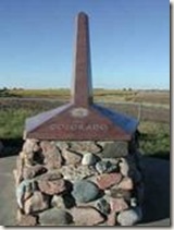 On May 8, 1855, Charles A. Manners set a monument made of cast iron on the bluff west of the Missouri River at 40° north latitude. In 1855-56 Manners surveyed 108 miles westward from this cast iron monument establishing the base line, the boundary between Kansas and Nebraska and established the Initial Point of the Sixth Principal Meridian.
The monument has the words Colorado on its west face, Kansas on the south face and Nebraska on its north face. This baseline continues westerly from the initial point and terminates at the summit of the Rocky Mountains, approximately 21 miles west of Boulder. The baseline is the longest baseline in the Centennial United States.
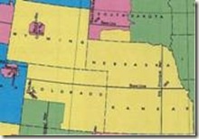
Why is the line between Kansas and Nebraska important to Weld County? That line, the 40° north latitude line, happens to be the southerly boundary of Weld County. All subsequent east-west township lines were surveyed to be parallel to this baseline. The map to the right illustrates the vast area that is controlled by the baseline and the Sixth Principal Meridian.
 The Sixth Principal Meridian starts at the initial point and runs in a true north-south direction. The northern terminus was on the southerly bank of the Missouri River. Thanks to the movement of the river, this point is now in the Missouri River. The southern terminus is the south line of the state of Kansas. All north-south township lines run in a true north to south direction. They are not parallel to the Sixth Principal Meridian line due to the fact that they converge at the north pole. This creates the difficultly in surveying and laying out square sections on a sphere. The problem was minimized by making corrections on the east-west township lines at 24 mile intervals north of the baseline. Anyone traveling north or south should notice the ‘jog’ in the road at the baseline, which is Weld County Road (WCR) 2, and the correction lines of WCR 50 and WCR 98. The ‘jogs’ are a result of the correction in section lines that helped to compensate for the “square on a sphere” problem. Other lines were surveyed to help control the location of the township lines. These lines were run true north and south and were called Guide Meridians. The correction lines mentioned above were also known as Standard Parallels as they were parallel to the baseline.
Township Lines were set six miles apart from each other going north and south from the 40th Parallel North and Range Lines were set six miles apart west of the Sixth Principal Meridian. The townships were numbered, starting with one for the first six mile increment, two for the second and so forth, giving each township a number subscript. The first township is called Township One North, the second Township Two North, etc. The Range Lines were numbered from the Sixth Principal Meridian (P.M.) going West again, in six mile increments. The first Range West of the 6th P. M. is called Range One West, the second Range Two West and so forth.
Once the Township Lines and Range Lines were in place, the surveyors started subdividing these areas into one mile rectangular parcels known as sections. They would start at the southeast corner of the Township, go west one mile, then north six miles, marking each "half-mile" and "mile" corner. At each mile or section corner, they would survey to the east and connect to the section corner already in place and make any corrections needed for alignment. This continued from east to west across the township.
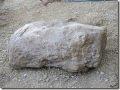 Monuments were placed every half mile and described in the surveyor’s notebook so that later surveyors could identify that marker as genuine. The picture on the left is a section corner stone that was recently recovered while surveying near the town of Grover.
The stone is shown on its side, but when originally placed it would have been upright. Marks were originally placed on the stone to indicate the number of miles west and north of the southeast township corner. You can faintly see the marks on this stone which was originally set in 1869. If stones were not readily available, surveyors would remove sod from approximately a 2’ by 4’ area in all four directions from the corner and stack this sod where the section corner would be. Next, they drove a wooden stake through the sod. The stake was marked with lines like the stone. This type of monument was called a “pit and mound”. Stones were permanently set and not easily removed, however the pits and mounds were easily destroyed. Prairie fires burned the stakes and stampeding buffalo obliterated the mounts. By in large, the location of the original markers are still used today as the original location of the section corners, even if there is reason to question the accuracy of how they were set.
It’s important to remember what it would be like to be an original surveyor in this area. The surveys of Weld County took place in the 1860’s. The Civil War was raging, Wyatt Erp was only twelve years old. The Native American and the Settlers were hostile to each other. The Sand Creek Massacre happened in this time period. The wild, wild west was not yet in full swing but gun slingers were present. Railroads were beginning to appear. Gold was discovered in the area called Auraria and in the mountains and once the land was surveyed, settlers came to homestead and populate Weld County.
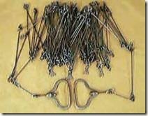
Surveyors measured the land by using a 66’ long Gunthers Chain as seen in the picture below.
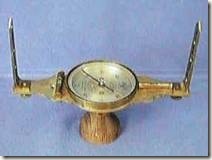
The direction of their travel was determined by a compass, as seen in the picture below.
Crews were made up of 5 to 7 men. These men worked from sunrise to sunset and lived in camp sites. Life was not easy for the early surveyors. Food was shot along the way. Work proceeded summer and winter. They were outside and faced the elements every day. Reports were sent back to the Surveyor Generals office of Native Americans discharging their weapons at them and disrupting their camps with midnight raids. Many workers feared for their lives. The crews would survey and walk more than 10 miles per day. Surveying time was much longer and more difficult when surveying in the townships around the major rivers in the county. Surveyors were required to describe the vegetation encountered and they were required to rate the soil and state an opinion on the ability to use this land for farming. These records were to be used by people wanting to move to Weld County and homestead. However, the records may not have been as accurate as hoped because it seems surveyors were not as good at rating soil as they were in surveying.
Early surveyors were often teased about being “nomads with sticks,” trying to make a curved planet fit into a flat system. What happened when the surveyor connected to the Section Corners on the Township Line along the North of the Township or the Range Line bordering the west side of the Township and did not quite measure the exact distance when he checked in? It was impractical to go back and re-survey the previous work and make any corrections so all error -- either short or long -- was thrown in to the last one-half mile along the northern and western tiers of the township.
The early surveyors completed one heck of a task with what today would be considered very primitive equipment. With our present day equipment, one person can measure to a small fraction of an inch and many miles in a very short time. I think if we were forced to survey today with the equipment and burdens they had back then, I doubt we could do the job nearly as good as they did. There are many adventurous and hardworking people that can be found in the early years of Weld County and certainly the original surveyors should be listed among them. They truly helped “form” and “shape” the county.
References: Bureau of Land Management
American Surveyor Magazine
Professional Surveyors Association of Nebraska
Kansas Society of Land Surveyors
Did You Know?
The West was measured by surveyors using Gunthers Chains -- 66 feet at time.